Text
List Help
This
is the Text List tabbed page for the Federal Aviation Administration (FAA)
Special Use Airspace (SUA) Website. This page allows users to view scheduling
data for Special Activity Airspace (SAA) including SUAs, Air Traffic
Control Assigned Airspaces (ATCAAs), Military Training Routes (MTRs), and
Aerial Refueling Routes/Anchors (ARs) that is active
or scheduled to be active within the next 24 hours in a table format. The page
also contains Notice to Airmen (NOTAM) data for Temporary Flight Restrictions (TFRs).
Once a TFR NOTAM is issued, the NOTAM data is available for display as an
active airspace on the SUA Website.
All
altitudes will be displayed as flight levels (FL) unless received as above
ground level (AGL), which will be indicated by an asterisk. In addition,
airspace schedules that are submitted as ‘up to but not including’ the maximum
altitude will display a less than sign (<) to the left of the scheduled
maximum altitude.
Navigation
Tabs
Use
the navigational tabs to navigate to Graphic
Map tabbed page which displays SAA scheduling and TFR NOTAM data in a
graphical map format.
Data
Update Information
If
the Auto-Refresh checkbox is checked the SUA Website data is refreshed once
every 5 minutes for display. When unchecked, the data will remain static and
unchanged. However, to verify the latest SUA, ATCAA, AR, and MTR information,
call the local Flight Service Station at 1-800-WX-BRIEF. To verify the latest
TFR data, contact the United States NOTAM Service (USNS).
Schedules or NOTAM IDs that expire will be removed in near real-time.
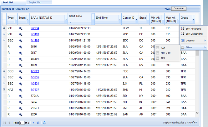
Column
Data
The
SAA and TFR data is displayed within the following
column headers. It may be sorted or filtered to display specific data and then
downloaded as needed into an Excel file for additional formatting.
Type – Type of Airspaces or Temporary Flight
Restrictions include:
SAA types of Alerts, ATCAAs, Military
Operation Areas, Prohibited Areas, Restricted Areas, Warning Areas, Aerial
Refueling Routes/Anchors, VFR Military Training Routes, IFR Military Training
Routes, Slow Speed Low Altitude Training Routes, and Other which includes
Orbits Areas
TFR types of 91.137 Disaster/Hazard
Areas, 91.138 Disaster Areas in Hawaii, 91.139 Emergency Air Traffic Rules,
91.141 Proximity of the President and Other Parties, 91.143 Proximity of Space
Flight Operations, 91.144 Flight Ops during Abnormally High Barometric Pressure
Conditions, and 91.145 Vicinity of Aerial Demonstrations and Major Sporting
Events, 99.7 Special Security Instructions and 44812 Unmanned Aircraft Systems
(UAS) Public Gatherings (UASPG).
Zoom – Displays a ![]() icon for each schedule which opens the
corresponding airspace image within the SUA Map
icon for each schedule which opens the
corresponding airspace image within the SUA Map
SAA/NOTAM
ID – List of Special Use
Airspaces, Military Training Routes, Aerial Refueling/Tanker Routes, and Temporary Flight Restriction NOTAM IDs
Start
Time – Scheduled start
time and date of SUA, MTR, AR, or TFR (MM/DD/YYYY HH:MM) in Zulu
End
Time – Scheduled end time
and date of SUA, MTR, AR, or TFR (MM/DD/YYYY HH:MM) in Zulu
Center
ID – List of center IDs
associated with specific airspaces
State – List of states in the
Min
Alt – Scheduled minimum
or low altitude of a SUA, MTR, AR, or TFR in 100s of feet (FL or AGL)
Max
Alt – Scheduled maximum
or high altitude of a SUA, MTR, AR, or TFR in 100s of feet (FL or AGL)
Group
Filter - Allows the user to filter the text list to
view schedules for one or more group types including SAA, MTR/AR, or TFR
Sort
Data
The
Type, SAA/NOTAM ID, Start Time, End Time, Center ID, State, Max Alt, and Min
Alt column data may be sorted by selecting the column header or clicking the
arrow to the right of the column header name to display a dropdown menu of sort
options.
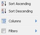
Once
selected, an arrow will appear below the column heading to indicate the current
sort order.
NOTE: In order to close
the sort feature the user will need to click on the
outside of the Text List area to close the dropdown menu.
NOTE: To remove the sort and reset the data to its
default display, select the Reset button.
Filter
Data
To filter column data by type, SAA/NOTAM ID,
center ID, state, max alt, min alt, or group select the corresponding column
header to display a dropdown menu of sort options. One or more columns may be
used in conjunction to drill down to specific data.
To filter by type, click the arrow to the
right of the Type column header and select one or more corresponding checkboxes
to drill down to a specific type of schedules/NOTAM IDs.
To view a specific group of schedules/NOTAM
IDs, click the arrow to the right of the Group column header, mouseover Filters
and select one or more of the group checkboxes provided. Groups include SAA,
MTR/AR, and TFR.
NOTE: In order to close
the filtering feature user will need to click on the outside of the list area
to close filter menu.
NOTE: To remove the filter and reset the data to
its default display, select the Reset button.
Download
Data
To create a file of the SAA or TFR data for
downloading, select the Download button. Then select Open to view
data or Save to save the file in a file
directory.
NOTE: If, after selecting Download, the option to open is not
available, you must Save the file and open file using Excel to set a
default application for the SUA download file type.
Airspace
Types
TYPE: ATCAA
Areas - A
DEFINITION: An ATCAA (ATC Assigned Airspace)
area is an airspace of defined vertical/lateral limits assigned by FAA Air
Traffic Control.
PURPOSE: ATCAA areas are established for the
purpose of providing air traffic segregation between the specified activities
being conducted within the assigned airspace and other Instrument Flight Rules
(IFR) air traffic.
TYPE: Aerial
Refueling Routes/Anchors - AR
DEFINITION: An aerial refueling route/anchor
is airspace used by military tankers that routinely refuel other military
aircraft along published altitudes (in most cases above 10,000 feet AGL).
PURPOSE: Aerial Refueling Routes/Anchors are
identified to inform non-participating pilots of the potential danger from
activities being conducted. This airspace is not prohibited as
long as other aircraft provide vertical or lateral separation from the
refueling aircraft. Contact the assigned FSS for AR details.
TYPE: IFR
Military Training Routes - IR
DEFINITION: An instrument flight rule (IFR)
military training route is airspace below 10, 000 feet MSL developed to be flown, to the maximum extent possible, under IFR or
instrument mode.
PURPOSE: IRs are used by the Department of
Defense and associated Reserve and Air Guard units for
the purpose of conducting low altitude navigation and tactical training in both
IFR and Visual Flight Rules (VFR) weather conditions below 10,000 feet mean sea
level (MSL) at airspeeds in excess
of 250 knots indicated airspeed (IAS).
TYPE: Alert
Areas - L
DEFINITION: An alert area is an airspace
wherein a high volume of pilot training activities or an unusual type of aerial
activity is conducted, neither of which is hazardous to aircraft.
PURPOSE: Alert Areas are depicted on
aeronautical charts for the information of nonparticipating pilots. All activities within an Alert
Area are conducted in accordance with Federal Aviation Regulations, and pilots
of participating aircraft as well as pilots transiting the area are equally
responsible for collision avoidance.
TYPE: Military
Operations Areas - M
DEFINITION: A MOA is airspace
established outside of Class A airspace area to separate or segregate certain
non-hazardous military activities from IFR traffic and to identify for VFR
traffic where these activities are conducted.
PURPOSE: The purpose of a MOA is to inform
nonparticipating pilots that IFR traffic may be cleared through a MOA if IFR
separation can be provided by Air Traffic Control (ATC). Otherwise, ATC will
reroute or restrict nonparticipating IFR traffic. Examples of activities
conducted in MOAs include, but are not limited to: air
combat tactics, air intercepts, aerobatics, formation training, and
low-altitude tactics.
TYPE: Other - O
DEFINITION: This type is used for all other
airspace types listed on the website including orbit areas. An orbit area or
flight track is an airspace that may appear as a circle, figure eight, or other
configuration within a single flight level between FL260 and FL310.
PURPOSE: Orbit areas are established to
support the operation of the E-3 Airborne Warning and Control System (AWACS).
Flight is maintained within the lateral confines of the assigned orbit area
which is not considered to be blocked airspace. During the mission, the ARTCC
may request temporary reduction of the assigned orbit
pattern length or altitude change to resolve any traffic situation.
TYPE: Prohibited Areas - P
DEFINITION: A prohibited area is airspace
established under 14 Code of Federal Regulations (CFR) part 73 provisions,
within which no person may operate an aircraft without permission of the using
agency.
PURPOSE: Prohibited areas are established when
necessary to prohibit flight over an area on the surface in the interest of
national security and welfare. They normally extend from the surface upward to
a specified altitude, with a "continuous" time of use rule.
TYPE: Restricted Areas - R
DEFINITION: A restricted area is airspace
established under 14 CFR part 73 provisions, within which the flight of
aircraft, while not wholly prohibited, is subject to restriction.
PURPOSE: Most restricted areas are designated
joint use and IFR/VFR operations in the area may be authorized by the
controlling ATC facility when it is not being utilized by the
using agency. Restricted areas are depicted on en
route charts. Where joint use is authorized, the name of the ATC controlling
facility is also shown.
TYPE: Slow
Speed Low Altitude Training Routes - SR
DEFINITION: A slow speed low altitude training
route is airspace for aircraft operating below 250 knots and between 250 feet
and 1,500 feet AGL.
PURPOSE: SRs are identified to inform
non-participating pilots of the potential danger from activities being
conducted. Non-participating aircraft are not prohibited, but must use extreme
caution when in the vicinity of a slow route and contact the assigned FSS
within 100 nautical miles (nm) of the SR.
TYPE: VFR
Military Training Routes - VR
DEFINITION: A visual flight rule (VFR)
military training route is airspace at 10,000 feet MSL and below that is
generally developed to be flown under visual conditions or VFR.
PURPOSE: VRs are used by the Department of
Defense and associated Reserve and Air Guard units for the purpose of
conducting low altitude navigation and tactical training under VFR below 10,000
feet MSL at airspeeds in excess of 250 knots IAS.
TYPE: Warning
Areas - W
DEFINITION: A warning area is airspace of
defined dimensions, (extending from 3 nm outward from the coast of the
PURPOSE: The purpose of a warning area is to
warn nonparticipating pilots of the potential danger
from activities being conducted. A warning area may be located over domestic
waters, international waters, or both.
TFR Types
Temporary
Flight Restriction (TFR) types as per 14 Code of Federal Regulations (CFR),
Section numbers as follows:
TYPE: CFR
91.137 Disaster/Hazard Areas - HAZ
PURPOSE: Is the effect of a natural hazard (flood, volcanic eruption,
earthquake, or landslide) that affects the environment, and leads to financial,
environmental and/or human losses.
Disaster/hazard situations that
warrant regulatory measures to restrict flight operations for a specified
amount of airspace, on a temporary basis, in order to
provide protection of persons or property in the air or on the ground.
TYPE:
CFR 91.138 Disaster Areas in Hawaii (HI) - HID
PURPOSE: Clarifies the operating requirements
for temporary flight restrictions in the vicinity of national disaster areas in
the state of Hawaii. This action proposes to change the title of the regulation
used to manage aircraft operations near hazard or disaster areas.
TYPE: CFR
91.139 Emergency Air Traffic Rules - EMERG
PURPOSE:
These security-related TFRs advise of the issuance and operations under
emergency air traffic rules and regulations that govern flight operation, the
use of navigation facilities, and designation of that airspace in which the
rules and regulations apply. TFRs issued in accordance with 14 CFR section
91.139 may be issued by the FAA Administrator (or designee), the Chief
Operating Officer of the ATO, FAA ATO Headquarters, or the ATO Director of
System Operations Security.
TYPE: CFR
91.141 Proximity of the President and Other Parties - VIP
PURPOSE: No person may operate an aircraft
over or in the vicinity of any area to be visited or traveled by the President,
the Vice President, or other public figures contrary to the restrictions
established by the Administrator and published in a NOTAM.
TYPE: CFR
91.143 Proximity of Space Flight Operations - SPC
PURPOSE: When a Notice to Airmen (NOTAM)
is issued in accordance with this section, no person may operate any aircraft
of
TYPE: CFR
91.144 Flight Ops during Abnormally High Barometric Pressure Conditions - HBP
PURPOSE: Temporary restrictions on flight
operations during abnormally high barometric pressure conditions. When any
information indicates that barometric pressure on the route of flight currently
exceeds or will exceed 31 inches of mercury, no person may operate an aircraft
or initiate a flight contrary to the requirements established by the
Administrator and published in a NOTAM issued under this section..
TYPE:
CFR 91.145 Vicinity of Aerial Demonstrations and Major Sporting Events - EVT
PURPOSE: Gives the FAA authority to establish TFRs to protect persons or property on the ground or in the air, to maintain
air safety and efficiency, or to prevent the unsafe congestion of aircraft in
the vicinity of an aerial demonstration or sporting event.
TYPE: CFR
99.7 Special Security Instructions - SEC
PURPOSE: Each person operating an aircraft
in an Air Defense Identification Zone (ADIZ) or Defense Area must, in addition
to the applicable rules of this part, comply with special security instructions
issued by the Administrator in the interest of national security, pursuant to
agreement between the FAA and the Department of Defense, or between the FAA and
a U.S. Federal security or intelligence agency.
TYPE: 44812
UAS Public Gathering - UASPG
PURPOSE: 44812 UAS Public Gathering TFRs refer
to Temporary Flight Restrictions for Unmanned Aircraft Systems (UAS) over large
public gatherings, authorized by Title 49 of the U.S. Code, Section 44812.
TFR
Details
The
details of a TFR may be viewed within the Text List tabbed page in an
expandable section located below each NOTAM ID by clicking the + sign displayed
at the beginning of the row or within the TFR Details page. The TFR Details
page can be viewed by selecting the NOTAM ID listed in the SAA/NOTAM ID column
for the TFR. The TFR Details page contains the actual text of the NOTAM along
with a small graphic if a TFR shape is available. A larger printable graphic
can be viewed by clicking on the graphic image or the Click for Large Map button.
Users may
view the NOTAM text in XML, AXIM, or via its shape file using the links
provided at the top of the TFR Details page.
SUA
Website Disclaimer
Depicted Special Activity Airspace (SAA) and Temporary
Flight Restriction (TFR) data may not be complete. Pilots should use this
information for planning purposes only. For the latest information, call your
local Flight Service Station at 1-800-WX-BRIEF
or contact air traffic control en route.
Contact
Information
Contact Federal Aviation Administration at 800
Independence Avenue, SW, Washington, DC 20591
Phone: 1-866-TELL-FAA (1-866-835-5322)
Customer Support: Hours of Operation are 24 hours a day, 7 days a week. Phone:
866-466-1336
Email: 7-AWA-NAIMES@faa.gov